About Solocator - GPS Field Camera
Solocator is a GPS camera for fieldwork or when you need photos for proof. Overlay and stamp photos with location, direction, altitude, date & time taken. With the Industry Pack (In-App Purchase), capture field notes such...
Solocator is a GPS camera for fieldwork or when you need photos for proof. Overlay and stamp photos with location, direction, altitude, date & time taken. With the Industry Pack (In-App Purchase), capture field notes such as project name, photo description, company or username.
Solocator is used by many industries, government agencies and professionals across the globe for photo documentation.
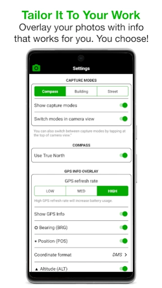
TAILOR OVERLAY INFORMATION TO YOUR NEEDS
Select the information you need to capture & stamp on your photos:
+ GPS position (Latitude & Longitude in various formats) ± Accuracy
+ UTM/MGRS coordinate formats (Industry Pack)
+ Compass direction–bearing
+ Altitude (Metric & Imperial units)
+ Tilt & Roll angles
+ Crosshair
+ Local date & time based on your GPS location
+ Local time zone
+ UTC time
+ Show compass
+ Street address (Industry Pack)
+ Show cardinal direction in Building mode, e.g. North elevation of a building face.
+ Option to use abbreviations or Unicode characters for direction, position and altitude.
CAMERA
Overlays are designed for both back and front selfie cameras. Supports pinch zoom, plus other standard camera controls, including self-timer, flash and exposure.
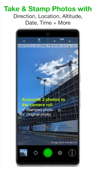
AUTOSAVE PHOTOS TO CAMERA ROLL
Take and autosave two photos at once: one stamped with the selected overlays and the original photo with no overlays.
SORT, SHARE OR EMAIL
+ Photos are sorted by time, location, distance from current location and project name if using the Industry Pack.
+ View photo direction and location in map view and navigate there.
+ Share photos individually or as a zip file via the share sheet.
+ Email photos including the following information:
- Exif metadata
- Compass direction
- GPS position ± accuracy
- Altitude
- Tilt & Roll
- Date & time taken
- Street address (Industry Pack)
- Elevation of building face viewed
- Link to maps so the receiver can navigate there easily
INDUSTRY PACK (In-App Purchase) “One-time charge”
EDITABLE NOTES OVERLAY
Stamp your photos with "Project name", "Description" & “Watermark”. The Project Name field could be used as a job or ticket number. The Watermark field is typically used for company or username. You can also edit these fields later.
CUSTOM EXPORT FILENAME
Define your photo export filename from a selection of fields: Project Name, Description, Watermark, Street Address, Date/Time, Number# and the Custom text field.
BATCH EDIT NOTES OVERLAY FIELDS
Select multiple photos from the library and edit Project Name, Description & Watermark fields in one go.
STREET ADDRESS & UTM/MGRS
Add street address to your overlay or use UTM/, UTM Bands & MGRS coordinate formats instead of Lat/Long.
AUTOSAVE OR EXPORT PHOTOS TO CLOUD STORAGE
Autosave original and stamped photos to Google Drive, Dropbox, and OneDrive (Personal & For Business), including SharePoint Sites and Teams. You can also save photos in date or project name subfolders - automatically. Or select and export photos later.
PHOTO DATA in KML, KMZ & CSV
Along with photos, email or export photo data and notes in KML, KMZ or CSV formats. Both email and export buttons are customisable to suit your data requirements.
TRACK PHOTOS IN MAP VIEW
View photos by direction, the distance between photos, and the area of photos taken.
REFINE & LOCK GPS LOCATION
Ideal for those working in and around buildings; to improve your GPS location. You can also use it to lock the asset position you're photographing.
COMPACT VIEW
Switch off Compass, Building and Street modes and only show the GPS info bar on top of photos for a more compact view.
IMPORTANT NOTE - DEVICES WITHOUT A COMPASS
From v2.18, we have made Solocator accessible for incompatible devices that do not have a compass. These devices are without a magnetometer (magnetic sensor), which means the compass and some direction features in the app won’t function as designed. However, when you change/update to a device with a compass, all directional features will be enabled to work as intended.
Previous Versions
Here you can find the changelog of Solocator - GPS Field Camera since it was posted on our website on 2016-12-24 09:32:58.
The latest version is 2.5.7 and it was updated on 2024-04-19 18:49:41. See below the changes in each version.
Solocator - GPS Field Camera version 2.5.7
Updated At: 2024-02-12
Changes: - Updated photo quality selection for autosaving, exporting and emailing photos. This will assist users who require smaller file sizes for storing photos.
- Also added an option to apply photo quality compression for original photos when exported
- Reordered and separated some settings for easier use
Solocator - GPS Field Camera version 2.5.6
Updated At: 2024-01-29
Changes: Standard App
- Support for ultra wide-angle camera with pinch zoom
- Remember camera zoom level
- Option to share original photos from Solocator app library
- Edit/change geospatial information and formats after taking photos
- Bug fix for compass jumping
- Save large files to internal storage
Industry Pack
- UI changes to Lock GPS Location screen
- Add or edit text before taking photos. Tap Project name or Description field
- User-defined filename field separator
Solocator - GPS Field Camera version 2.40.14
Updated At: 2023-12-22
Changes: - Tilt, Roll & Crosshair overlays in camera or stamp on photos & added to EXIF metadata
- Date format options, UTC time & local time zone options
- Timer added to the camera
NEW IN INDUSTRY PACK
- Autosave photos to Google Drive, Dropbox & OneDrive
- Batch edit notes overlay fields; Project Name, Description & Watermark
- Photos in map view by direction, distance & area of photos taken
- Optimised KMZ file
- Changed UI of notes overlays on photos in library
- Zipped files use Project filename
Solocator - GPS Field Camera version 2.37.5
Updated At: 2023-08-10
Changes: • Added a selection of photo sizes for KMZ files.
• Added photo number as an option in user defined photo marker titles in KML/KMZ files.
• Bug fix to include photo details for outlook email users.
Solocator - GPS Field Camera version 2.35.21
Updated At: 2020-10-22
Changes: . This update includes fix for saving photos to camera roll
RECENT UPDATE
. Russian & Spanish languages support
. Custom export filename structure for photos
. Suffix No. added to exported photos with same filename
. Notes overlay background gradient
. Option to select GPS refresh rate
. Position accuracy is now a separate selection for external GNSS users
. Set Solocator as default Camera
. User defined list to create photo marker titles in KML/KMZ files
. Compression when emailing large files
Solocator - GPS Field Camera version 2.35.6
Updated At: 2020-09-29
Changes: . Russian & Spanish languages support
. Custom export filename structure for photos
. Suffix No. added to exported photos with same filename
. Notes overlay background gradient
. Option to select GPS refresh rate
. Position accuracy is now a separate selection for external GNSS users
. Set Solocator as default Camera
. Improved KML/KMZ file export for Windows - Google Earth & ArcGIS
. User defined list to create photo marker titles in KML/KMZ files
. Zip compression when emailing large files
Solocator - GPS Field Camera version 2.25.3
Updated At: 2020-01-10
Changes: . Various bug fixes including a fix for some devices with Set Parameters failed issue on launch.
. Added shutter button on/off switch in settings.
Solocator - GPS Field Camera version 2.24.5
Updated At: 2019-11-22
Changes: Various bug fixes including:
- Fixed camera zoom issue.
- Fixed geospatial overlay stamp not displaying correctly.
- Modification to camera shutter sound working with device settings.
Solocator - GPS Field Camera version 2.23.39
Updated At: 2019-11-04
Changes: - Various bug fixes
+ Added DMS.s and ±DMS.s with one decimal place format.
+ Added option to email or export photos as a zip file. See archiving section in settings.
+ You can now zoom into photos in the library after they’ve been taken.
+ Export and email photo data in KML, KMZ or CSV file formats & attach maps (Industry Pack).
- Fixed Auto Focus for some devices.
- Fixed issue for some devices not connecting to the Industry Pack (In-app purchase).
- Fixed crashes for some Kyocera devices.
Solocator - GPS Field Camera version 2.23.32
Updated At: 2019-10-28
Changes: + Added DMS.s and ±DMS.s with one decimal place format.
+ Added option to email or export photos as a zip file. See archiving section in settings.
+ You can now zoom into photos in the library after they’ve been taken.
+ Export and email photo data in KML, KMZ or CSV file formats & attach maps (Industry Pack).
- Fixed Auto Focus for some devices.
- Fixed an issue where some devices couldn’t connect to the Industry Pack (In-app purchase).
- Fixed crashes for some Kyocera devices.